"Did you ever wake up to find a day that broke up your mind?
Destroyed your notion of circular time?"

Typhoons and the Philippines - A Marriage Made by Mother Nature!
The Philippines just happens to sit in absolutely the worst geographical location in the world for severe tropical weather. There will always be typhoons here.
PHILIPPINES
6/2/20262 min read
Typhoons In The Philippines - A Reality!
Before we moved to the Philippines, I received a comment from a friend about typhoon landfalls in that country. His comment revealed his own assumption that most typhoons landed on the island of Samar.
Back in the mid 80's when I lived and worked in the Subic Bay area, I was a Weather Forecaster assigned to the Naval Oceanography and Meteorology Command at the Cubi Point U.S. Naval Air Station. One of our primary functions at that office was to provide weather forecasting services for the Commander, Naval Forces Philippines, and in coordination with the official Philippine organization now named the Philippine Atmospheric, Geophysical and Astronomical Services Administration (PAGASA).
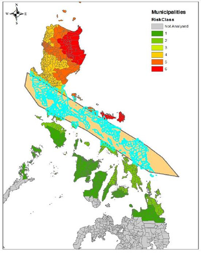
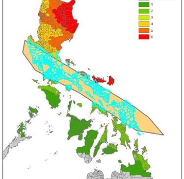
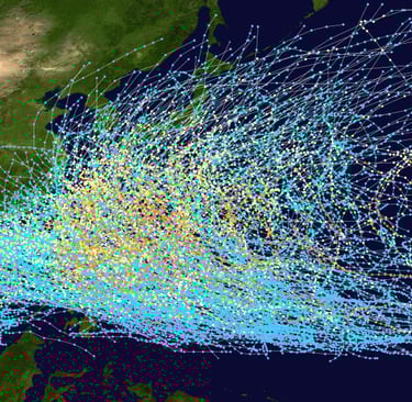
Typical typhoon track across the Philippines (20-year event)
The purpose of our forecasting effort there was much more than just military/strategic and also involved services directed at the protection of life and assets there and throughout the region. The two major weather events that kept us the most busy were the seasonal southwest monsoon (Habagat) and typhoon forecasting and tracking.
So when my friend suggested Samar as being the center of typhoon alley, I had to take back my own opinion and do some quick research. Although Samar Island is one of the more eastward located and facing islands, it's proximity in the archipelago only means that if a storm does in fact hit the central Philippines, Samar will usually be the first to feel the effects. This is not to mean that Samar always take a direct hit, but Samar is definitely located in an above average area for storm tracks. Luzon, the northernmost and largest of the Philippine islands, is the largest target for the majority of developed storms that track through the region.
As seen in the graphic above, storm intensity and frequency are historically assigned tracks to areas of the Philippines. The farther north you go, the higher the "risk class" of damage and destruction from storms. And likewise, the farther south, the safer one becomes related to these destructive storms.
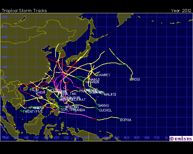
Storm tracks in 2012 - A Roll of the Dice
Of course, there will always be deviations from the norm - take Typhoon Bopha (Pablo) in Dec 2012 for example. It was the second such dangerous storm to hit Mindanao in two years. Looking at the 2012 storm track chart above, and with all atmospheric ingredients and scenarios considered, it's all really up to Mother Nature's roll of the dice. There is nowhere in the Philippines that is completely safe from typhoons, but as mentioned earlier, the risk factor decreases with a decrease in lattitude.
I told my friend, "I'll trade you one Living in Tornado Alley for 2 Living in Typhoon Alleys any day of the year!"
(Originally posted 2/24/2013 - Revised 2026)